Serpentine Hot Springs
By the HotSpringsFind editorial team · How we compile records · Reviewed September 2026
Serpentine Hot Springs is a primitive hot spring listed near Nome, Alaska. Reported soak temperature: 106°F. See the visit fact sheet.
Current status
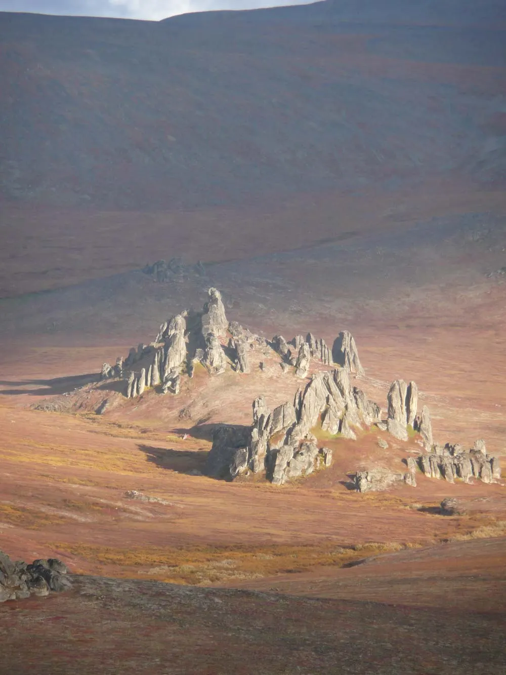
NPS-maintained hot springs oasis (source up to 170F piped into an enclosed bathhouse tub where creek water is mixed to temper) among granite tors in Bering Land Bridge National Preserve ~100 mi north of Nome — FREE bunkhouse (sleeps ~12, first-come first-served) and outhouse, reachable ONLY by bush plane to a 1,100-ft unmaintained gravel airstrip, floatplane, boat, foot, or winter snowmachine on staked trails from Nome/Shishmaref; no roads, no cell, self-sufficiency mandatory.
Checked September 2026 · verified against an official source · 8 sources ↓
Before you go
- Status: Open — last verified below — confirm via NPS Bering Land Bridge — 'Reaching Serpentine Hot Springs' (no roads; air taxi/airstrip/snowmachine access; no permits; prohibited vehicles; artifact protection).
- Cost: Reported free access — fees and permits can change, confirm before visiting.
- Getting there: No verified hike distance on record — confirm the route and road conditions.
- Water: Reported soak temperature 106°F — always test the water before entering.
- Rules: Reported clothing-optional; pets reported not allowed — confirm current rules.
- Conditions: check weather, fire closures, and land-manager alerts the week you go — mountain access changes seasonally.
- Reservations/permits: None — no reservations or backcountry permits; free use of airstrip, bathhouse, bunkhouse. Commercial transport via NPS-licensed air taxis from Nome.
- Best time to go: Summer (Jun-Sep) for mildest conditions and hiking among the tors; winter for a steamy escape but only for experienced, fully self-sufficient travelers with sat comms. Fly-outs are weather-dependent year-round.
- Clothing reality: No posted policy; the enclosed bathhouse is private. This is a sacred Inupiaq healing site (Iyat, 'cooking pot') — traditional protocol asks each bather to drink a half-to-one cup from the hot tap before entering; be respectful of Native users and customs.
- Kids: Allowed.
- Cell service: none — download maps and tell someone your plan.
- Accessibility: Extremely limited — floatplane/bush-plane transfer, soft airstrip, rough tundra ground; the bathhouse is a short walk from the strip on uneven terrain.
- NO ROADS — access by small plane to the unmaintained 1,100-ft gravel airstrip (elev ~460 ft, uphill grade, soft/rutted, VFR day ops, unattended), floatplane, boat, foot, or winter snowmachine via staked trails from Nome and Shishmaref; licensed air taxis out of Nome are the normal route — see NPS's Commercial Visitor Service Provider directory
- FREE, first-come first-served — no reservations, no backcountry permits issued; bunkhouse has ~12 bunks in 3 rooms, Coleman/propane and heat-drip stoves, cookware, water filters, bear-safe food locker — but BRING your own fuel, matches, food, sleeping bag, toilet paper, and pack out ALL trash
- Source water measured 140-170F — the bathhouse tub is tempered by a piped creek line; regulate before entering; overheating (especially with alcohol) can cause shock/heart failure per NPS — medical help is DAYS away
- CULTURAL SITE: sacred to Inupiat communities for millennia — do not disturb artifacts (federal felony); local elders' bathing protocol exists; report disturbance to the Nome preserve office
- Winter Oct-Apr: extremes to -50F, 4-hr January daylight, ice builds on bathhouse floors/walkways (treacherous footing), be prepared to dig out the outhouse; pack a week+ extra of any essential medication
- NO communication — no cell service in the preserve; satellite phone or ELT/PLB is the only lifeline; nearest hospital >80 mi (Nome), 3-4 hr response in OPTIMAL conditions; file an itinerary with someone
- Helicopters, ATVs and other off-road vehicles are PROHIBITED in the preserve
- Weather delays are the norm — storms build fast, low clouds obscure landmarks; budget extra days and supplies; sudden summer storms possible too
- Hazard: 140-170F scalding source water — temper with creek line before soaking
- Hazard: Extreme remoteness — >80 mi to hospital, no cell, satellite device essential
- Hazard: Arctic weather — sudden storms, -40/-50F winter extremes, travel delays of days
- Hazard: Ice-slicked bathhouse floors/walkways in winter
- Hazard: Bears — use the food locker; bear country throughout the preserve
- Hazard: Bush-flight risks — unmaintained airstrip, turbulence, VFR-only
- Hazard: Overheating/dehydration in the tub — avoid alcohol
About this spring
The most-visited site in Bering Land Bridge National Preserve — hot spring water piped into an enclosed bathhouse beside a year-round bunkhouse, ringed by massive granite tors. Sacred Inupiaq site (Iyat) used for millennia; gravel airstrip on site. Extreme remote travel — self-sufficiency essential; do not disturb artifacts.
The Bering Land Bridge National Preserve is one of the most remote protected areas of the United States, located on the Seward Peninsula. The National Preserve protects a remnant of the Bering Land Bridge that connected Asia with North America more than 13,000 years ago during the Pleistocene ice age. The majority of this land bridge now lies beneath the waters of the Chukchi and Bering Seas. During the glacial epoch this bridge was a migration route for people, animals, and plants whenever ocean levels fell enough to expose the land bridge. Archeologists debate whether it was across this Bering Land Bridge, also called Beringia, that humans first migrated from Asia to populate the Americas, or whether it was via a coastal route. Bering Land Bridge National Monument was established in 1978 by Presidential proclamation under the authority of the Antiquities Act. The designation was modified in 1980 to a national preserve with the passage of the Alaska National Interest Lands Conservation Act (ANILCA), which would allow both subsistence hunting by local residents and sport hunting. The preserve includes significant archaeological sites and a variety of geological features. The preserve has seen recent volcanic activity, with lava flows and lake-filled maars. Hot springs are a popular destination for tourists.
Text from the Wikipedia article “Bering Land Bridge National Preserve”, available under CC BY-SA.
Directions & trailhead access
No roads — air taxi to the gravel strip, or snowmobile ~100+ mi from Nome on staked winter trails.
Alaska geothermal context
Alaska's geothermal sites sit along the volcanically active Aleutian arc and scattered Interior fault zones. Most are reachable only by floatplane, boat, or long backcountry routes, and the realistic soaking season is short — roughly June through September. Treat every remote spring as a wilderness trip, not a roadside stop.
What a primitive site means here
Primitive springs have no facilities: no changing rooms, no trash service, often no maintained road to the pool. Expect natural rock or gravel bottoms, water temperature that varies by spot and season, and other visitors who may treat the site informally. Pack out everything you bring, test the water before entering, and leave the pool cleaner than you found it.
Best time to visit
June – September (Short Summer Access Window)Remote Alaskan geothermal sites have a brief accessible season — snow, ice, and limited road access close most areas outside summer. Midnight-sun June through early September offers the only realistic visiting window for most locations.
Fact sheet
| Reported soak temp | 106°F |
|---|---|
| Source temp (historical) | 106°F |
| Trail access | Recorded coordinates — access unverified |
| Access fee | Reported free — verify locally |
| Clothing policy | Reported clothing-optional |
| Pet policy | Reported no pets |
| Geothermal data reference | NOAA Thermal Springs List (1980 archive) |
| Check land status | NPS Bering Land Bridge — 'Reaching Serpentine Hot Springs' (no roads; air taxi/airstrip/snowmachine access; no permits; prohibited vehicles; artifact protection) |
Serpentine Hot Springs FAQ
Is Serpentine Hot Springs open right now?
NPS-maintained hot springs oasis (source up to 170F piped into an enclosed bathhouse tub where creek water is mixed to temper) among granite tors in Bering Land Bridge National Preserve ~100 mi north of Nome — FREE bunkhouse (sleeps ~12, first-come first-served) and outhouse, reachable ONLY by bush plane to a 1,100-ft unmaintained gravel airstrip, floatplane, boat, foot, or winter snowmachine on staked trails from Nome/Shishmaref; no roads, no cell, self-sufficiency mandatory. (Status verified against an official source, last checked September 2026.)
Is Serpentine Hot Springs free?
Serpentine Hot Springs is listed as free to access in Nome Census Area, Alaska. Fees and rules change — verify current status with the land manager before visiting.
What temperature is Serpentine Hot Springs?
Serpentine Hot Springs has a reported soak temperature of 106°F and a historical source temperature of 106°F in survey records. Historical data may not reflect current conditions — always test water before entering.
Is Serpentine Hot Springs clothing optional?
Serpentine Hot Springs is listed as traditionally clothing-optional in directory records. Confirm current rules before visiting, as policies change.
How do you access Serpentine Hot Springs?
Serpentine Hot Springs is on public land — verify current road access, fees and rules with the land manager before visiting.
Sources & references
- NPS Bering Land Bridge — 'Reaching Serpentine Hot Springs' (no roads; air taxi/airstrip/snowmachine access; no permits; prohibited vehicles; artifact protection) — official · 2026-09
- NPS Bering Land Bridge — Bunkhouse and Amenities (3 rooms ~12 bunks, stoves/fuel BYO, bear locker, first-come first-served, pack out trash) — official · 2026-09
- NPS Bering Land Bridge — Visiting in the Winter (-50F extremes, icy bathhouse floors, 80+ mi to hospital, no cell/sat-comms guidance) — official · 2026-09
- NPS Bering Land Bridge — Information for Pilots (airstrip 65x51.118N 164x42.177W, 1,100 ft gravel, unattended, VFR day ops, tie-downs for 2 planes) — official · 2026-09
- NPS — Serpentine Hot Springs: An Overview (Iyat 'cooking pot'; most-visited preserve site; free year-round bunkhouse/bathhouse) — official · 2026-09
- NPS historic Iyat brochure (water up to 170F vs stream <50F; bathhouse rebuilt 2012; hypothermia/shock warning; tors) — official · 2012
- PubMed — 'Native healing in Alaska. Report from Serpentine Hot Springs' (spring temps 60-77C; bathhouse plumbing: spring + creek pipes regulate tub; bathing protocol incl. drinking spring water first) — official · 1984
- NPS — Geology of Serpentine Hot Springs (two thermal areas — Serpentine + Arctic Hot Springs; meteoric water heated via fractured Oonatut granite pluton) — official · 2026-09
Details above were verified against the named sources on their listed dates — conditions change, so recheck before traveling. · How we verify our data · Report a correction
Your private trip notes
Saved only in this browser — not published or shared.No private notes yet
Keep access details and observations for your own planning.